|
INSTRUCTIONS
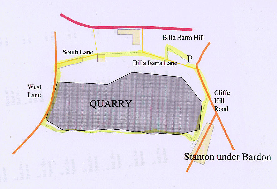
From the car park, walk
out onto the road, and turn left, up to the junction. Here turn right, onto
Cliffe Hill Road. After a short distance, turn right onto the footpath,
which goes up some steps, over the dismantled railway line, and down the
steps on the other side. Continue as the footpath turns into a road behind
the houses, with the allotments on the right, and then bends round the the
left. As soon as you have turned left at this point, turn right, continuing
behind the houses along a track, eventually reaching a footpath which goes
off to the right and into the trees. Follow this footpath, as it goes over a
bridge, (signposted "Quarryman's Way") ignoring the turns to the right, and
go uphill, bending around to the left.
Follow the edge of the Quarry, going along the top of fields, and ignoring
the footpath off to the left, and eventually walking under four sets of
power lines before coming out next to the Quarry Entrance on West Lane.
Cross over the railway bridge, and the Quarry Entrance, and walk along the
pavement until you reach the junction with South Lane on the right (just
after the ponds). Walk along South lane, until the end, where there is a
footpath sign, pointing straight on, between a house and a field. Walk along
this path, which goes along a raised disused railway embankment, between the
trees, until you come out on Billa Barra Lane. Walk straight on, along Billa
Barra lane, until you reach a footpath sign on the left. Go over the stile,
and up to the summit. From here, you can return straight down the hill, to
the car park at the bottom.
GRID REFERENCES
In this day of increasing
technology, quite a few walkers have GPS Systems with them. These 6 figure
grid references are the ones I used when I did the walk.
(All are SK)
468 112
469 109
466 105
448 108
453 115
458 116
162 113
468 112
MAP
Map
© Leicesterwalk 2003. This is a rough map, and we
accept no responsibility for any loss or injury resulting from its use. |
|
I walked this route on a January afternoon,
and it was quite windy up on the top of the Quarryman's Way part of the
route. However, the views over the surrounding countryside made up for this.
The Quarry on your right is hidden for most of the journey, although, at the
point when you can see it, it is interesting to look at the different rock
layers visible in the opposite side of the quarry.
The view from Billa Barra stretches across to
Bardon Hill (the highest point in Leicestershire) and far beyond, to East
Midlands airport. In the other direction, the village of Thornton can be
seen, as well as Bagworth and Stanton under Bardon.
Please
contact me if you have any queries or comments about this walk!
Daniel Spencer
|