NEW MAP
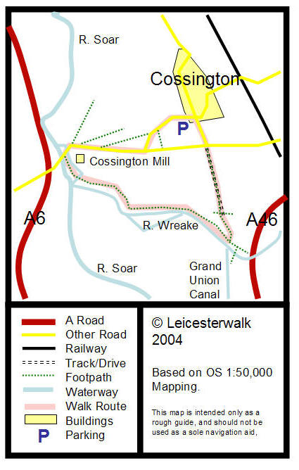
Start at the crossroads in Cossington, near the
car park and the pub, facing west down Platts Lane. Begin to walking down
Platts Lane without deviation for about half of a kilometre, until it joins
Syston Road. Continue west down Syston Road, towards Rothley.
After passing a gravel pit on your right, and
the former Cossington Mill Restaurant on your left, cross “half way” over
the bridge, so you are on a river island. Follow the footpath sign to your
left, making sure that the Cossington Mill is on your left at all times.
Here, on the river, there is a lock. Continue down this path, and over a
footbridge. Just after the bridge is the confluence of the River Wreake and
the River Soar. You will follow the path alongside the River Wreake. While
walking down this path, you will have to climb over several styles, and you
will notice another lock, and, behind the lock a river island.
Continue along the path for about 1½ km,
until you reach another footbridge. This is yet another confluence, this
time between the River Wreake and the Grand Union Canal. The footpath splits
in three. One path continues along the River Wreake, and under the Fosse
Way; another goes across the footbridge and down the Grand Union; and the
final one bears left at the footbridge (without crossing it), and across a
field. For the purposes of this walk, take the latter (I will, at a later
stage, detail walks talking you along these different routes).
At the style leading on to the field, you
will be able to see three sets of buildings. Nearest the A46, you will see a
small ruined building; left of that you will see a collection of farm
buildings; and left of that you will see another house. Walk across the
field towards that house, and down its drive. At the end of that drive, you
will be at a t-junction. Continue straight out of the drive, and across the
junction, which will take you directly back to the crossroads in Cossington
where you began.
|