|
From
the car park at the East end of Thornton Reservoir dam, walk along the path
along the
 eastern
side of the reservoir. At the eastern most point, cross over the river as it
enters the reservoir. After crossing, don’t follow the reservoir path, but
instead go ahead onto the Leicestershire Round footpath. Shortly, there is a
junction on the left, with two footpaths. Use the sign board as you enter
the woods, aiming to leave the woodland via the second footpath. Head
diagonally across the wood, turning left just after the abandoned farm
equipment, then right in that field. Walk across the field and through
"Ashley's Wood" bending left at the end of the woodland, eventually reaching
the road. Upon reaching the road, turn right, then take the first footpath
on the left. eastern
side of the reservoir. At the eastern most point, cross over the river as it
enters the reservoir. After crossing, don’t follow the reservoir path, but
instead go ahead onto the Leicestershire Round footpath. Shortly, there is a
junction on the left, with two footpaths. Use the sign board as you enter
the woods, aiming to leave the woodland via the second footpath. Head
diagonally across the wood, turning left just after the abandoned farm
equipment, then right in that field. Walk across the field and through
"Ashley's Wood" bending left at the end of the woodland, eventually reaching
the road. Upon reaching the road, turn right, then take the first footpath
on the left.
Where
paths cross, turn left, walking next to the field boundary to the road. At
the road, turn right. Keep on this road (don’t take the turning on the
right), until just before Manor Farm. Here, take a footpath off to the left.
Keep on this path until it meets another path, then turn left, and follow
the path along the field boundary, (under power lines) eventually turning right and walking
diagonally across a field, heading just left of Bagworth Park Farm. This
part of the route is very very muddy.
Where
the paths cross, go straight on, cross the railway line, and at the
cross-path, go straight on again, heading under a power line and onto a
road.
At the
main road, turn left, then keep right on this road (ignore the turning on
the left signposted
Thornton)
until you come to a footpath.
Here turn left, and
walk along this path, crossing the railway line. Where the path splits, turn
right, coming out on a residential street in Thornton. Turn right, and then
at the main road turn right again, and walk back through Thornton to the car
park 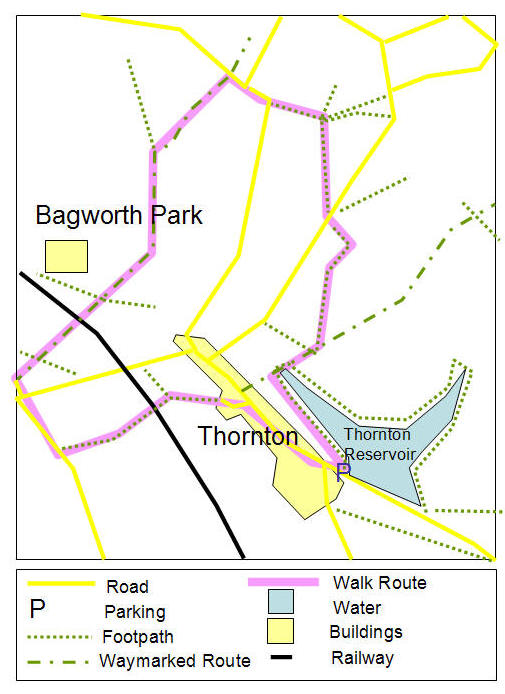
Map copyright
Leicesterwalk 2003 |
|
This
walk shares part of its route with another Leicesterwalk route, around
Bagworth, Barleston and Thornton.
I
have walked most of this route now. Unfortunately, since the map came out,
much of the area has been planted with trees, and extra paths have been
added, making navigation much harder. A lot of the stiles are
overgrown and some are broken or rotten. It is vital to take a map and
compass on this route, as the compass really is useful in the national
forest site. It is not a walk for the novice.
Sadly, I did not have time to complete the full walk, and so took a detour
back to Thornton.... so I'd be grateful for any comments etc.
D. Spencer
History
Click
HERE
to find out about the history of Bagworth on our sister site - Semper Eadem. |