|
From
the Groby Pool Car Park, take the path left out of the car park, walking
alongside the road. At the gate on the left, turn left, heading towards the
A50 along a footpath. Where the path comes up to the A50, turn left, walking
down the embankment, then right, under the bridge, coming out alongside the
church into the village.
Turn
left, then tae the first road on the right, just before the pub. Walk up
this road, passing a college on the right. After the college, take a
footpath on the left (just before the cemetery) walking along the back of
the cemetery to Sachevral Way. Cross over this busy road, and continue along
the footpath which turns sharply to run parallel to the M1 to a bridge.
Don’t cross over this bridge, but instead turn left, and follow the path
across the field, towards the A46. After crossing a stream, and the route of
a dismantled railway, you find the path blocked by the A46. Turn left here,
and walk alongside (but a little distance away from) the A46, until the
bridge. At the bridge, turn right, crossing over the A46, then after the
bridge, take the footpath heading away from the road across the fields,
towards the industrial estate.
Follow
this path, which turns into a track running down the left hand side of the
TNT depot. After the depot, you meet the line of the old Leicester to Swannington Railway. Here, turn left, and walk along the track which runs
behind the scrap yard, ad then alongside the brook, crossing over a bridge.
Keep on this track to the end, where you emerge on
Station Road,
behind the Railway Inn.
Don’t
walk out onto the road, but instead, turn left, walking across the open
tarmac area to a footpath sign. Follow this footpath between two field
fences. The path soon becomes narrow and tree-lined, following the path of a
small stream.
Emerging at the Shell petrol station on the A50, cross over this busy road
with great care, and continue along the footpath on the other side, still
following the stream. The footpath skirts a sports field, then meets the
Rothley Brook, eventually running alongside the A46 to a tunnel.
Walk
through the tunnel under the road, then, as the path splits at a bridge,
take the left fork towards the cemetery. Walk alongside the cemetery to the
road. Turn right, and then take a footpath a few yards on the left.
At the
cross-path, turn left, and walk across the fields, parallel to the road.
Ignore the turning off to the left, and keep walking, around the edge of a
large field, before heading steeply downhill to cross a track. Cross over
the track, then cross the stream at a footbridge, rejoining the track, which
runs through the old “pick-your-own” farm.
At the
road, turn right, and walk along the road back to the car park.
Map: 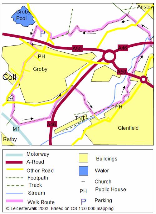
This map was drawn for Leicesterwalk, and is based on Ordinance Survey
1:50,000 mapping. It is for use as an aid to following the above
instructions, and should not be used instead of a real map. We recommend
that you always carry a real OS map and compass. We cannot accept any
responsibility or liability for any loss, damage or injury incurred while
following this walk, or using this map. While we make every effort to ensure
the accuracy of our map and instructions, we cannot be held responsible for
any error. |